Coming in from the Atlantic Ocean, Tropical Storm Florence is expected to make landfall Thursday as a level 3 hurricane or greater, steered by winds that could guide it as far south as Florida or as far north as New England. Meanwhile, Hurricane Olivia is forecast to hit the Hawaiian Islands as a tropical storm on Wednesday, bringing heavy rains just two weeks after Hurricane Lane caused major flooding. A look at what forecasters are predicting for those storms and the rest of the season:
What do we know about the storms right now?
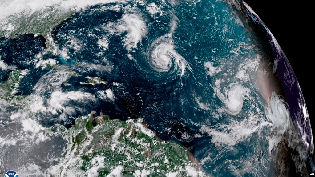
Tropical Storm Florence was gathering strength Saturday, with the National Hurricane Center expecting it to become a hurricane overnight. Five days out from expected landfall, there's still wide uncertainty about where it will hit and at what intensity, but the latest models show that it's most likely to make landfall in the southeast U.S., between northern Florida and North Carolina. Still, there's a chance it could be pushed farther north and strike along the mid-Atlantic or New England coast, threatening to make landfall between Virginia and Massachusetts. No matter where it lands, there's a chance it could stall out and pummel the coasts for days. The latest models on Saturday show that it's becoming less likely the storm will veer north and miss the mainland U.S. entirely. At minimum, residents along the East Coast are being told to expect heavy rainfall and storm surges, with the possibility of heavy winds.
In this image provided by NOAA, Tropical Storm Gordon approaches the United States
Forecasters are also keeping an eye on two storms gathering behind Florence. Tropical Storm Helene was expected to reach the Cabo Verde islands on Saturday but is predicted to miss the mainland U.S. A tropical depression that was upgraded to Tropical Storm Isaac on Saturday is headed toward the Caribbean and brings a greater chance of curving north toward Puerto Rico and the mainland, potentially as a hurricane. It's still uncertain whether Hurricane Olivia will make landfall in the Hawaiian Islands, but at minimum meteorologists believe it will come very close and deliver a new round of rainfall. The National Weather Service has also issued a typhoon watch in the U.S. territory of Guam, where Tropical Storm Mangkhut is approaching from the east and is expected to bring damaging winds by Monday evening.
When will we have a better idea of whether they pose a threat?
Each day brings a clearer picture of the risks posed by the storms. Jeff Masters, co-founder of the Weather Underground service, says airplanes gathering weather information began flying into Florence on Saturday, which should provide data that will lead to a major boost in the reliability of models on Sunday. Isaac's route is still wildly uncertain and will be for days. Forecasters are more confident that Olivia will affect Hawaii, with its path and intensity sharpening in the next few days.
What factors give Florence a chance of being a particulary strong hurricane?


 Reply With Quote